2 minute read

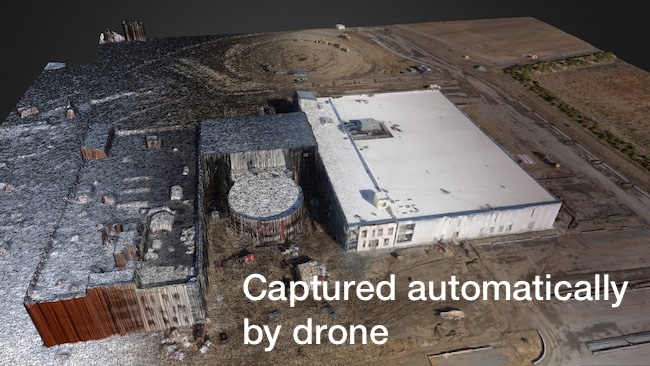
 Automated 3D map generated by drone
UAV technology is now moving at an incredible rate. So much so that your lowly Phantom or Inspire 1 is now capable of being a far more useful tool than you could have possibly imagined when you bought it.
Aside from video, UAVs are often used for a multitude of other uses such as agriculture, building site surveying, and oil rig inspections amongst many others. Usually if you want to move beyond straightforward video with a Phantom or Inspire you would need to purchase an entirely new multi-rotor system, often at great expense, and more often than not it would need to be a self build.
Now a company called Drone Deploy has written an app and developed a subscription service that promises to take your UAVs capabilities beyond anything you could have first imagined.
At first look it appears that the app simply allows your UAV to fly a set of waypoints taking pictures as it goes before stitching them together. This is all well and good, and provides some very high resolution imagery that can be incorporated into Google Earth etc. Such a use is great for taking aerial views of construction sites, deforestation of areas to name two applications.
What is truly ground-breaking is the other capability that the app allows. Those who have used Apple Maps will be aware of the rather cool 3D view that you can see of major cities when you zoom in. Some aspects of this can be improved, but it remains a pretty cool demonstration.
Drone Deploy will enable anyone with an Inspire 1 or Phantom to make the same kind of 3D imagery. Some demos are available on the site and they are impressive, although low resolution in some cases. However I am told that the system is capable of far higher resolution texturing and model detail for offline use. Over several visits all of this imagery can be combined to make what is effectively a timelapse of the surveyed sites’ development using a layering system.
The system uploads the photos and data from the aircraft via LTE or WiFi connection through your tablet or smart phone, so you will need good network coverage to make it work. Checks are made for issues such as blurring, and if any problems are detected the UAV is instructed to fly back to that position to take a replacement shot.
What use could it be? Site surveying (since the data is mapped to within a couple of cm accuracy), building planning, integration with standard video for visualisations to name a few. The capabilities of Drone Deploy go much further, including agricultural crop surveying to identify areas of risk and to help with crop distribution and volumetrics of mining site stockpiles.
While the app is free, the imagery processing is handled by a subscription system on the Drone Deploy website. Some of the options aren’t cheap, but if you are involved in any of these areas of expertise then the costs would soon repay themselves due to the money saved through better decisions. Not least because unlike other solutions to such mapping Drone Deploy stitches the data together within minutes rather than hours.
Currently Inspire 1, Phantom 3, and Matrice 100 compatibility is in beta testing, while the Phantom Vision 2 compatibility is live requiring Android 4.4 or above. iOS compatibility with DJI products is in the works.
This looks like truly disruptive technology, bringing such capabilities within the reach of far more people using a wider range of inexpensive equipment.
Tags: Production

RedShark 2020 @ All rights reserved.

Comments